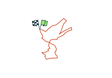
![](/images/other/stat-length.png)
![Tocht Te voet Rüdesheim am Rhein - Hildegardweg - Photo](https://media.geolcdn.com/t/1900/400/383cc12c-ca7c-4bec-bb31-c2bbae795e1e.jpeg&format=pjpeg&maxdim=2)
Hildegardweg
SityTrail - itinéraires balisés pédestres
Tous les sentiers balisés d’Europe GUIDE+
![Lengte](/images/other/stat-length.png)
![Max. hoogte](https://static1.geolcdn.com/siteimages/upload/files/1508320355ic_sort_altitude_max_24dp.png)
![Positief hoogteverschil](https://static1.geolcdn.com/siteimages/upload/files/1508320355ic_sort_den_pos_24dp.png)
![Km-Effort](/images/other/stat-length.png)
![Min. hoogte](https://static1.geolcdn.com/siteimages/upload/files/1508320355ic_sort_altitude_min_24dp.png)
![Negatief hoogteverschil](https://static1.geolcdn.com/siteimages/upload/files/1508320355ic_sort_den_neg_24dp.png)
![Boucle](https://static1.geolcdn.com/siteimages/upload/files/16400158638029165_repeat_loop_refresh_sync_direction_icon.png)
![Te voet](https://static1.geolcdn.com/sitytour/trail-icons/100.png)
2h06
Moeilijkheid : Gemakkelijk
![Scan deze QR-code om de tocht te openen in de SityTrail-applicatie](https://capi.geolives.com/qq0zvz2zws4bq2lad0pu/sitytour/trails/3099065/qr.png?size=200)
Gratisgps-wandelapplicatie
Over ons
Tocht Te voet van 6,7 km beschikbaar op Hessen, Rheingau-Taunus-Kreis, Rüdesheim am Rhein. Deze tocht wordt voorgesteld door SityTrail - itinéraires balisés pédestres.
Beschrijving
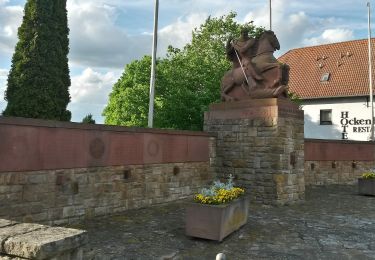
Symbol: Weißes Schild. Oben weinrotes Quadrat, darauf weißer Nonnenkopf. Darunter in Schwarz "Hildegardweg"
Website: https://www.naheland.net/de/outdoor/wandern/hildegard-von-bingen-pilgerwanderweg
Plaatsbepaling
Opmerkingen
Wandeltochten in de omgeving
![Tocht Te voet Ockenheim - Generationenweg - Photo](https://media.geolcdn.com/t/375/260/61dae334-bc68-4664-87ce-cbe8bf1a4704.jpeg&format=jpg&maxdim=2)
![Te voet Te voet](https://static1.geolcdn.com/sitytour/trail-icons/100.png)
Te voet
![](/images/other/stat-length.png)
![](https://static1.geolcdn.com/siteimages/upload/files/16400158638029165_repeat_loop_refresh_sync_direction_icon.png)
![Tocht Te voet Ockenheim - Scharfes Gericht - Photo](https://media.geolcdn.com/t/375/260/61dae334-bc68-4664-87ce-cbe8bf1a4704.jpeg&format=jpg&maxdim=2)
![Te voet Te voet](https://static1.geolcdn.com/sitytour/trail-icons/100.png)
Te voet
![](/images/other/stat-length.png)
![](https://static1.geolcdn.com/siteimages/upload/files/16400158638029165_repeat_loop_refresh_sync_direction_icon.png)
![Tocht Te voet Geisenheim - Geisenheimer Rundweg O - Photo](https://media.geolcdn.com/t/375/260/23caf65e-d1b0-432b-8cb1-95d45052c5b3.jpeg&format=jpg&maxdim=2)
![Te voet Te voet](https://static1.geolcdn.com/sitytour/trail-icons/100.png)
Te voet
![](/images/other/stat-length.png)
![](https://static1.geolcdn.com/siteimages/upload/files/16400158638029165_repeat_loop_refresh_sync_direction_icon.png)
![Tocht Te voet Geisenheim - Geisenheimer Rundweg M - Photo](https://media.geolcdn.com/t/375/260/0aad0740-e5ea-4eab-b9e4-1dc6f9e6e635.jpeg&format=jpg&maxdim=2)
![Te voet Te voet](https://static1.geolcdn.com/sitytour/trail-icons/100.png)
Te voet
![](/images/other/stat-length.png)
![](https://static1.geolcdn.com/siteimages/upload/files/16400158638029165_repeat_loop_refresh_sync_direction_icon.png)
![Tocht Te voet Geisenheim - Geisenheimer Rundweg I - Photo](https://media.geolcdn.com/t/375/260/a7b95e33-3a2b-44fc-8c9b-988116704fbb.jpeg&format=jpg&maxdim=2)
![Te voet Te voet](https://static1.geolcdn.com/sitytour/trail-icons/100.png)
Te voet
![](/images/other/stat-length.png)
![](https://static1.geolcdn.com/siteimages/upload/files/16400158638029165_repeat_loop_refresh_sync_direction_icon.png)
![Tocht Te voet Geisenheim - Geisenheimer Rundweg J - Photo](https://media.geolcdn.com/t/375/260/e4502c24-35a9-4c74-a651-9299cfecf071.jpeg&format=jpg&maxdim=2)
![Te voet Te voet](https://static1.geolcdn.com/sitytour/trail-icons/100.png)
Te voet
![](/images/other/stat-length.png)
![](https://static1.geolcdn.com/siteimages/upload/files/16400158638029165_repeat_loop_refresh_sync_direction_icon.png)
![Tocht Te voet Geisenheim - Geisenheimer Rundweg D - Photo](https://media.geolcdn.com/t/375/260/9223db67-e7da-4277-bf63-0b96616ead54.jpeg&format=jpg&maxdim=2)
![Te voet Te voet](https://static1.geolcdn.com/sitytour/trail-icons/100.png)
Te voet
![](/images/other/stat-length.png)
![](https://static1.geolcdn.com/siteimages/upload/files/16400158638029165_repeat_loop_refresh_sync_direction_icon.png)
![Tocht Te voet Rüdesheim am Rhein - Rheingauer Klostersteig Zuweg Assmannshausen - Photo](https://media.geolcdn.com/t/375/260/0b549e65-574a-4424-acfe-276db4f7f1c5.jpeg&format=jpg&maxdim=2)
![Te voet Te voet](https://static1.geolcdn.com/sitytour/trail-icons/100.png)
Te voet
![](/images/other/stat-length.png)
![](https://static1.geolcdn.com/siteimages/upload/files/16400158638029165_repeat_loop_refresh_sync_direction_icon.png)
![Tocht Te voet Geisenheim - Geisenheimer Rundweg F - Photo](https://media.geolcdn.com/t/375/260/c4e2e677-d8d1-4f54-8616-f5083e0a1cdf.jpeg&format=jpg&maxdim=2)
![Te voet Te voet](https://static1.geolcdn.com/sitytour/trail-icons/100.png)
Te voet
![](/images/other/stat-length.png)
![](https://static1.geolcdn.com/siteimages/upload/files/16400158638029165_repeat_loop_refresh_sync_direction_icon.png)